Kuwait Energy
EL-12-211107
54
The Mishrif Formation is of Middle Cretaceous age and at B9NE is approximately 2,200 ft
(675 m) thick. It consists mainly of massive, shallow marine carbonates. Regionally, it is
developed into two major facies: massive platform carbonates containing rudists, and a
deeper marine facies of thinner bedded, fine-grained argillaceous limestone. The B9NE
field area is located on the platform close to its north-east edge, between the prolific
Mishrif reservoirs of Halfayah, Majnoon and West Qurna in Iraq, and the much tighter
basinal facies of Jufeyr in Iran. The reservoir is dominated by foraminiferal and rudist
packstones with some rudist-rich horizons. Karstified intervals may also be present.
Stacked, non-communicating reservoir sub-units or stratigraphic trapping (or both) are
expected.
The Lower Yamama Formation is of Lower Cretaceous age and at B9NE is nearly
2,000 ft (600 m) thick. It is regionally known as a massive oolitic to pellety limestone.
The Formation is highly over-pressured and can be divided into Upper and Lower
Members having significantly different reservoir pressure (this is reportedly a regional
phenomenon). Separate pressure regimes are expected within the Lower Member, and
possibly in the Upper Member as well, with stacked, non-communicating reservoir sub-
units and/or stratigraphic trapping. There is apparently little evidence of structural faulting
at the target horizons but reservoir compartmentalisation could be caused by areas of
poorer reservoir quality that act as flow barriers. However, these are not clearly defined.
KE has created top Mishrif and Lower Yamama depth maps using a simple depth
conversion. The structure clearly extends across the border at both reservoir levels and
the crest of the structure probably lies just within Block 9. KE has used these maps to
estimate the gross rock volume within Block 9 that is hydrocarbon bearing. A range of
possible OWC depths has been used based on reported ODTs. The southern boundary
of the reservoirs has been taken a short distance to the south of HOS-1 (Figure 3.7).
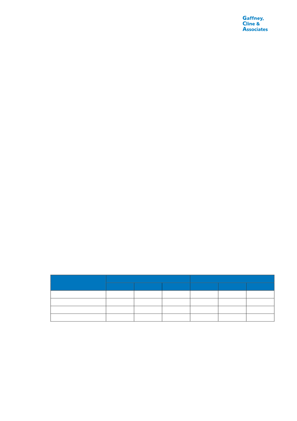
Table 3.2 summarizes the deterministic STOIIP and GIIP estimates made by KE. Gas
volumes were estimated using an average GOR of 386 scf/stb for the Mishrif and
1,700 scf/stb for the Lower Yamama. GCA has audited these estimates and considers
them to be reasonable, based on the limited data available to KE.
TABLE 3.2
STOIIP AND GIIP ESTIMATES, B9NE FIELD, BLOCK 9
Reservoir
STOIIP (MMBbl)
GIIP (Bscf)
Low
Best
High
Low
Best
High
Mishrif
1,361
2,612
4,925
525
1,008
1,901
Lower Yamama Upper
535
1,057
1,941
909
1,797
3,300
Lower Yamama Lower
77
255
724
131
434
1,230
Total
1,973
3,924
7,590
1,566
3,239
6,432
KE spudded the first exploration/appraisal well on 25
th
March, 2014 following de-mining of
the well site and access areas. It had reached a depth of approximately 1,300 m after
35 days; drilling and data acquisition are expected to take 6-7 months in total. De-mining
continues and once this is completed, 3D seismic data will be acquired. Further appraisal
wells, which would also be used as development wells, are expected to be drilled in late
2015/early 2016. If all goes well, a formal FDP could be submitted in 2017. KE believes
that it may be possible to start production in 2016 through an early production facility,
subject to regulatory approval.


